|
| Album | |
Neotectonics This is a study using multiple methods of earthquake geology to work on the active-fault systems, to know how they behave during coseismic and interseismic stages, to determine the short-term and long-term activity rates, and to present a better solution to earthquake hazard mitigation. This discipline embraces seismology, paleoseismology, structural geology, geodesy, geochronology and geomorphology. Example I: Surface deformation related to kink-folding above an active fault: Evidence from geomorphic features and co-seismic slips By means of a geomorphological study using 40m digital elevation model, structural reconstruction by field data, and related geodetic results, we reevaluate the geomorphic features in the Hsinshe area, where multi-step terraces have been previously documented and supposedly provide more information of the neotectonic history. Our results show that two kink-shaped scarps can be discriminated from other terrace risers, which are probably formed by folding instead of faulting as suggested by previous researchers. Two E–Wreconstructed hanging wall cross sections in the north and south show that the fault plane of Chelungpu fault flattens to the east and sinks to the south, creating a monoclinal hanging wall resembling a quarter hemisphere in terms of a 3D model. We propose a kinetic model to explain the surface monocline fold: it is developed when the fault plane presents a fault-bend, such as the case along the Chelungpu fault at Hsinshe. The co-seismic deformation from the 1999 Chi-Chi earthquake demonstrates that the model is probably valid. Furthermore, the higher terrace showing larger deformation indicates the influences of active structures on terraces have continuously acted for a long time. The westward tilting of the hanging wall terraces result from the action of the Chelungpu fault and its related structural geometry. Based on the optical-stimulated-luminescence age of 55.0712.6 ka of the highest terrace, we can compute the vertical rates across the main thrust and fold scarp in the hanging wall as 7.0 and 2.5 m /kyr, respectively.
Example II: Newly found Tunglo Active Fault System in the fold and thrust belt in northwestern Taiwan deduced from deformed terraces and its tectonic significance We found active faults in the fold and thrust belt between Tunglo town and the Tachia River in northwestern Taiwan . The surface rupture occurred in 1999 and 1935 nearby the study area, but no historical surface rupture is recorded in this area, suggesting that the seismic energy has been accumulated during the recent time. Deformed fluvial terraces aid in understanding late Quaternary tectonics in this tectonically active area. This area contains newly identified faults that we group as the Tunglo Fault System, which formed after the area's oldest fluvial terrace and appears at least 16km long in roughly N–S orientation. Its progressive deformations are all recorded in associated terraces developed during the middle to late Quaternary. In the north, the system consists of two subparallel active faults, the Tunglo Fault and Tunglo East Fault, striking N–S and facing each other from opposite sides of the northward flowing Hsihu River , whose course may be controlled by interactions of above-mentioned two active faults. The northern part of the Tunglo Fault, to the west of the river, is a reverse fault with upthrown side on the west; conversely the Tunglo East Fault, to the east, is also a reverse fault, but with upthrown side on the east. Both faults are marked by a flexural scarp or eastward tilting of fluvial terraces. Considering a Quaternary syncline lies subparallel to the east of this fault system, the Tunglo Fault might be originated as a bending moment fault and the Tunglo East Fault as a flexural slip fault. However, they have developed as obvious reverse faults, which have progressive deformation under E–W compressive stress field of Taiwan . Farther south, a west-facing high scarp, the Tunglo South Fault, strikes NNE–SSW, oblique to the region's E–W direction of compression. Probably due to the strain partitioning, the Tunglo South Fault generates en echelon, elongated ridges and swales to accommodate right-lateral strike–slip displacement. Other structures in the area include eastward-striking portion of the Sanyi Fault, which has no evidence for late Quaternary surface rupture on this fault; perhaps slip on this part of Sanyi Fault ceased when the Tunglo Fault System became active.
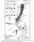
Example III: Co-seismic ground slips deduced from sub-pixel correlation of aerial photos: a case of 1999 Chi-Chi Earthquake (Mw 7.6) at Tsaotun in Central Taiwan We always suffer with the building collapse s and other severe damages , once the surface ruptures produced by large earthquake runs through an urban area. In order to assess the potential seismic hazard , it is essential to understand how an earthquake produces the surface rupture and other surface deformation . The more detail ed and complete inter-seismic and co-seismic ground slips rate we may obtain, the more reliable the subsurface fault geometry we may understand . By the fault geometry the coseismic surface rupture and deformation can be anticipated for the future earthquake. On Sep. 21, 1999 , Mw 7.6 Chi-Chi earthquake occurred in central Taiwan and caused a wide damage zone. At the Tsaotun area, the surface rupture not only broke along the Chelungpu fault ( CLPF) , but also the Ailiao fault (ALF) that is caused by the fault-bend of the CLPF . P revious study using sub-pixel correlation of SPOT satellite images has successfully retrieved coseismic ground displacement within damaged zone, but it did not accurately locate the position of surface rupture of CLPF and ALF due to the low resolution of SPOT images. In this study, high-resolution aerial photographs are used for the same purpose. Precise orthorectification and sub-pixel correlation are conducted to obtain more accurate co-seismic surface displacement. Our result shows the sharp changes in horizontal displacement across the surface ruptures of CLPF. By EW profiles across the rupture, the coseismic horizontal displacement can be shown by ca. 5 and 3.5 m toward the west and north respectively. The displacement in the northern segment is generally larger than the south, but it is opposite from the independent measurement of leveling . By above two datasets, we find the values of the net-slips are nearly the same, but the dip angle of northern segment is great er than that of the south . On the other hand, the profiles across the ALF show that the horizontal displacements gradually increase 1-2 meters mountainward, with a narrower changing zone in the southern segment. The maximum change is also located in the middle part of the southern segment. This reveals that the CLPF relatively bends faster and larger in the southern segment.
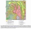
igure 1 Map showing the horizontal displacements during the 1999 Chi-Chi earthquake: (a) East-West component (b) North-South component. The surface deformation drawn in dark blue includes the ruptures and another monoclinal fold in the east (CGS, 1999b) . The coordinate system is UTM-N51.
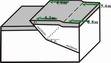
Figure 2 Schematic block diagram showing the fault geometry of the CLPF and the differential displacements in the south and north. |
||||
Last Update :
Monday, 2006-11-27
|
||||