Preliminary study of the neotectonic in
Luyeh area
I-Chin, Yen 顏一勤
Abstract
Taiwan is setting on the boundary between Philippine Sea plate and
Eurasian plate, the suture of two plates is remain at Longitudinal
Valley of eastern Taiwan. The active seismicity and rapid rates
of horizontal and vertical deformation are revealing active of orogeny.
In the southern of Longitudinal Valley is exists many neotectonic
geomorphologic evidences. In this study, we were investigated at
field work on the geomorphology and geology to analysis the neotectonic
feature of southern of Longitudinal Valley. We interpreted that
Longitudinal Valley Fault still push the southern of Longitudinal
Valley move to west and the block will be lock at Luyeh Fault. The
different geometry of surface deformation cause by the fault tip
variant of the Luyeh Fault, and the structures die out by plunging
in the south and north.
Introduction
Taiwan island is located the boundary between Philippine Sea plate
and Eurasian plate (Fig. 1). Rapid rates of horizontal and vertical
deformation and active seismicity amply demonstrate the current
vigor of the orogeny. In southern Taiwan, the South China Sea lithosphere
is subducting eastward under the Luzon arc. In north-eastern Taiwan,
the Philippine Sea plate is subducting northward under the Ryukyu
arc. The active Taiwan orogen is in the transfer zone between the
two opposite-facing arcs, and is a tandem suturing and tandem disarticulation
of a volcanic arc and a continental sliver to and from the Eurasian
continental margin.
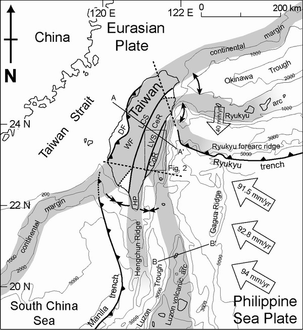 Fig. 1
The Longitudinal Valley between the Central Range and the Coastal
Range thus marks the boundary between rocks of Eurasian affinity
and rocks that originated on the Philippine Sea plate. GPS geodesy
shows that the rate of the North Luzon arc moving towards the Asian
continental margin is about 8.2 cm/yr in an azimuth of 310°, and
also shows that the rate of closure is about 40 mm/yr in the south
part of Longitudinal Valley. The dominant neotectonic structure
of the south part of Longitudinal Valley is the eastern dipping
Longitudinal Valley fault, along the eastern edge of the Valley.
The Luyeh fault is a reverse-slip fault which marks the westernmost
boundary of the suture zone with eastern dipping, and it reactivated
and caused the terrace to form a flexure scarp. No historic earthquake
rupture appeared in southern Longitudinal Valley, but Quaternary
terrace deforme revealed active faulting. The Longitudinal Valley
fault and Luyeh fault both are active fault in southern Longitudina;
Valley.
In this study, we separate three units-PingDin, GaoTai and Peinanshan,
of the south part of Longitudinal Valley. Our field investigations
on the geomorphology and geology was based on interpreted geomorphologic
feature with air-photo and 40m digital elevation model (DEM) of
Taiwan island in laboratory. Our goals in this paper is present
the neotectonic proof and try to explain the fault mechanism in
southern Longitudinal Valley area.
Geomorphologic Analysis
Based on air-photo and 40m DEM of Taiwan island interpretation,
we classified three types of terraces-fluvial terrace, alluvial
terrace, and landslide terrace; and four types of structure features-thrust
fault, normal fault, syncline form and anticline form, in southern
part of Longitudinal Valley(Fig. 2). After field investigation of
geomorphology and geology, the final display is characterization
as following:
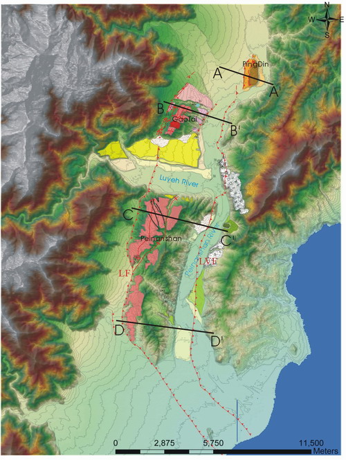 Fig.
2
Fig.
2
1. Terraces:
a. Fluvial terrace: The fluvial terraces in this
area could be separated to Luyeh River and Peinan River terraces
by different drainage. The Luyeh River terraces development along
the both sides of Luyeh River with 5 steps. Lungtien terraces are
the widest and along the north side of Luyeh River, and deformed
at 60m high terrace. The south side of Luyeh River remains several
tilting small terrace in the northern Peinanshan tableland. The
Peinan River terraces development along eastern and western side
of the Peinan River. In PingDin area, 4 steps were been formatted.
In the eastern side of Peinan River, the terraces setting on the
western of Costal Range in 5 steps. They also can find that terraces
cover over basement rocks.
b. Alluvial terrace: The old alluvial terraces
in this study are distribution on the top of the GaoTai and Peinanshan
tableland and had laterited. The young alluvial terraces are in
front of small valley with alluvial fan. This kind of terrace is
difficult to recognize tilting or not.
c. Landslide terrace: Landslide deposits are cover
over on western side of the Costal Range hills. In generally, the
landslide deposits contain large angular gravels with poorly sorted,
and included volcanic rocks that transport from Costal Range hills
.
2. Structure features
a. Thrust fault: The thrust faults in PingDin area
are along western scarp of three different steps terrace, and both
with eastern dipping. According to the height of basement rocks
decrease from eastern to western terrace, the thrust fault is younger
from eastern to western. The youngest one was formed only 2m height
scarp at southwestern terrace of PingDin platform, and also with
eastern dipping. The oldest one was extend to south to connect with
eastern dipping Longitudinal Valley fault, and across two parts
of western Costal Range hills and northeastern corner of Peinanshan
tableland (Fig.2 LVF). The other important eastern dipping fault
in westernmost of southern part of Longitudinal Valley was formed
the double thrust fault system in GaoTai area and extend to south
from Lungtien terrace to Taitung city with single thrust fault.
The specially in GaoTai is exist a western dipping thrust fault
in front of eastern side scarp of tableland.
b. Normal fault: The normal faults in this study
were presented in the northwestern part of Peinanshan tableland,
and trend to northwestern to southeastern way.. It was revealed
extension component in this region.
c. Syncline form: The syncline form extended from
central part of Peinanshan tableland in southern to under southeastern
part of Lungtien terraces. It’s the main structure controlled by
regional syncline deformation.
d. Anticline form: The anticline form of this study
almost behind of thrust faults. In the GaoTai area, the anticline
along the ridge at west of tableland and back of westernmost thrust
fault, and also exist in the top of tableland along northeastern
to southwestern way. The anticline in Peinanshan area is along geomorphologic
high extend in north to south way, and plunging to central part
of tableland.
In the PingDin area, three eastern dipping thrust faults in front
of second, third and fourth step of terrace. From the relief of
each step of terrace, the fourth step terrace more high than other
terraces, and also exposed basement rocks under the terrace. According
to basement rocks high than west terraces, the Longitudinal Valley
Fault can be extend to this thrust fault. And the others thrust
fault in the west side could be a new fault propagate from eastern
thrust fault (Fig. 3AA’).
In the GaoTai area, the western thrust fault was revealed double
thrust fault with anticline. And the opposite dipping thrust fault
was existed in the eastern side of the tableland, maybe formed by
a back thrust fault of anticline back limb. The Luyeh Fault, westernmost
thrust fault, is also active result in tilting terrace in the western
of tableland (Fig. 3BB’). The Longitudinal Valley Fault in this
region without exposure, and maybe exist under the Peinan River.
In the Peinanshan area, the Longitudinal Valley Fault in eastern
side of tableland, and cut through northeastern tableland and a
part of western Coastal Range hills. It also made syncline along
western side, and terminal in central tableland. The anticline setting
between syncline and westernmost thrust fault, and plunge to south
at central tableland. It was formed by westernmost fault cause of
fault propagation folds mechanism (Fig. 3CC’ and 3DD’).
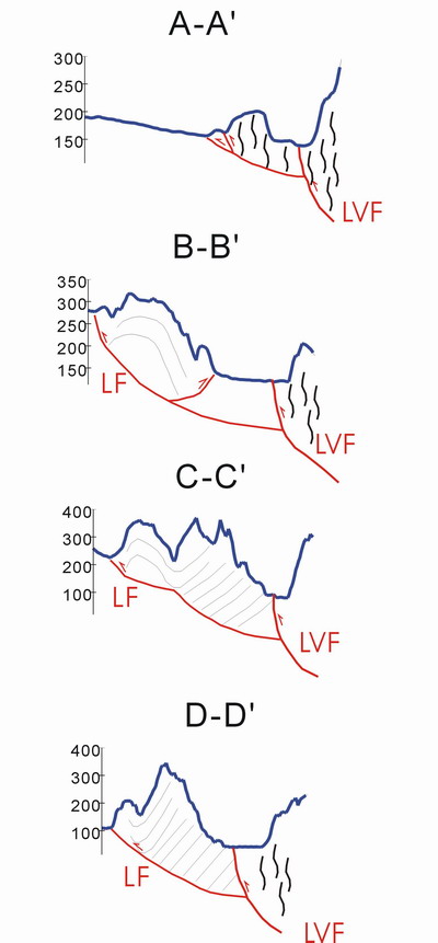 Fig.
3
Fig.
3
Discussion
Based on the field investigation of geomorphology and geology,
this study can conclude that structure mechanism in study region
is may be dominant by fault propagation fold with variant fault
tip line. The fault plane is different height of tip line under
westernmost thrust fault, and plunge to south and north with higher
fault tip at central part of fault. The Longitudinal Valley Fault
in this study also showed that was active fault with younger terrace
tilting, and the fault trace almost along Peinan River bed.
According to geodetic and leveling survey shows that the horizontal
velocity of eastern side of Longitudinal Valley Fault is move at
~310° and more faster than western side, the velocity between Longitudinal
Valley Fault and Luyeh Fault is decrease from eastern to western
(see Fig. 4) . It’s reveal the Longitudinal Valley Fault is more
active than Luyeh Fault, and fault plane lock at Luyeh Fault. The
leveling data of coseismic uplift rate about two earthquakes at
2003~2004 in Luyeh and Luyeh-Juayuan area, shows that Longitudinal
Valley Fault has uplift in eastern and deform with anticline in
west of Longitudinal Valley Fault (see Fig. 5a and 5b). The Luyeh-Juayuan
area also presented two different uplift rate between 0308 to S193,
it is provide the thrust fault in PingDin platform still active.
Both Longitudinal Valley Fault and Luyeh Fault are active and
eastern dipping. From the horizontal velocity distribution near
the fault, the Coastal Range still push to west and Longitudinal
Valley block was moved to west by deformation and locked at westernmost
thrust fault. The different fault tip depth made fold structure
plunge to north and south, and also formed fan-shaped distribution
of GPS vector direction.
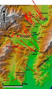 Fig. 4
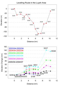
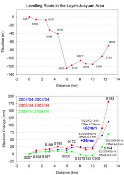
Fig. 5a Fig.
5b