Regional Planning Report on Geological Hazard
Management
for Southern Longitudinal Valley along Rye-long, Taitung
Tien-Huei Wang ¤ý¤ŃĽz
Report Summary
This document is a geological survey of area along peinan river
from rye-long community, kaotai, long-tein, across the luye river
to peinan mountain.(See Fig.1) Based on observation in the field,
former geological documentation, GPS data, and seismic events, we
provide reliable locations of fault system and deformation history
in recent years, and suggest their future activities. There are
some recommendations for facilities and construction plans or possible
modification to residents and government associated, in relation
to hazard management. Hazards which we mentioned are landslide,
surface deformation caused by earthquakes and by tectonic activities,
and earthquake events. The analytical limit bound us to give only
plausible land deformation details on condition of continuous tectonic
activity, or possible earthquake events.
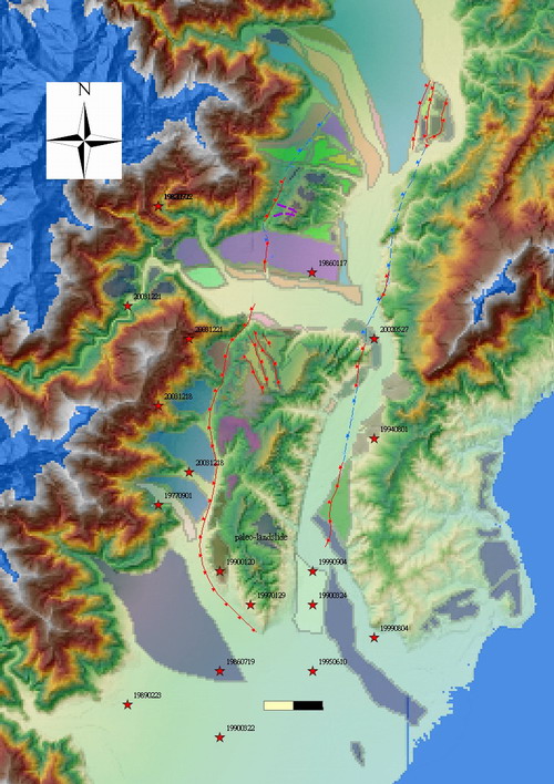
Fig.1 Report area: main structural raised area includes Pingding,
Kaotai, Longtien, Painanshan, Lichi village, and Taitung. Two major
thrust fault goes through southern longitudinal valley, one tends
to west side forming kaotai area and folding uplift of peinanshan.
The other, part of coastal range fault, is at east side of the valley.
Red stars with id marked as occur time are earthquake events magnitude
greater than 4.
Introduction
Previous understanding of geological tectonic motion
and local lithologic unit help us to clarify cause and effect of
some hazard. Taking precaution about possible future hazards, their
locations and properties are thus applicable.
1. Tectonic setting of Taiwan, Taitung
Region along Rye-long, to Taitung in the longitudinal valley is
under constant north-west trending pressure from the Philippine
sea plate, which directed toward Eurasian plate. (See Fig.2) Under
a relative velocity 82 mm/yr moving northwestward at 310˘X(Yu, Chen
and Kuo, 1997), north of report area is accumulating suture force
of thrusting and transforming to force parallel contact direction.
At the same time, The report region accommodates compression rate
increasing from north to south, which is theoretically logic since
more compression force locked or transformed in the north, and southern
part is catching-up with suturing. In these circumstances, coastal
range is uplifting with approximately 13 mm/yr (controlled by terrace
C14 dating) within 1000yr. Also, Long-range uplift vertical rate
is around 20 mm/yr. These tectonic continuous motion offer great
effort to form Kaotai and Peinanshan area, together with several
flat stages of river terraces like Longtein, and river fan tilting
as north of Kaotai.
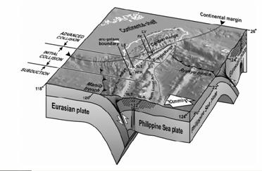
Fig.2 (C. P. Chang, J. Angelier, C.Y. Huang, C. S. Liu, 2001)
Tectonic structure of plates under Taiwan: East of Taiwan is composed
of Luzon volcanic arc collision with the Central Range, and Logitudinal
Valley in between as material deposited from either Central Range
or Coastal Range, deep marine mudstone, and fluvial peinanshan conglomerate.
2. Lithological Units
On Geological map (Fig.3) there are four basic lithical sets: Lichi
m Álange( mudstone and mixture of exotic lithology blocks), peinanshan
conglomerates(well cemented, sub angular, not well-sorted metamorphic
pebbles), modern fluvial deposite conglomerates ( layered, not well
cemented, clear with imbrication, slightly graded), and metamorphic
slates of Central Range. Distribution of them integrate whole picture
of this area. In relation to different properties of rock type,
we might expect at edges of mountain range or scarps, slumping type
would be different. Also, where Lichi m Álange locates attribute
to easy erosion or river cut.
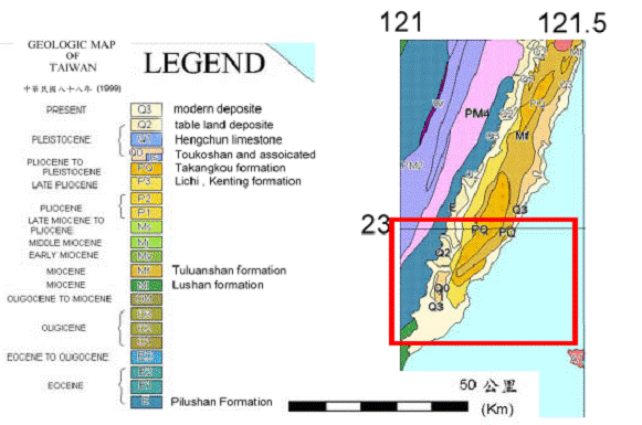
Fig.3 Geological map regional 0
3. Historical Seismic events
There were not much large seismic events during 1973-2003 occurring
in northern part of survey region, besides Chengkung earthquake
in December ,2003, which ruptured along a east-dipping, trending
north 10 degree east plane (Yi-Min Wu, Y.G. Chen, J. C. Wu, AGU,
2004), mostly referred as Chihshang fault. Chihshang fault include
only part of Coastal range fault, coseismic movement focused on
north of Pingding, but there is some uplift at Kaotai and southern
tip of Coastal Range for almost 5cm vertical and 3~5cm horizontal
toward east to south east(GPS data by Liwei Chen, 2005). Through
these latest events, we might earn a concept of recent activities
that the fault system mainly migrate to thrust, plus right-lateral
faulting of Coastal Range fault. With several substructures and
partitions in northern and southern tips of the region, we would
expect deformation increase at Pingding, and eastern edge along
Peinanshan.
Read table.1 compare with Fig.1 to see historical events distribution.
date x y depth magnitude
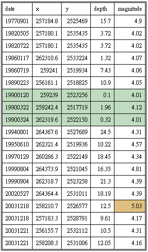
Table.1 Green background mark three events rupture near surface,
all of them are south of Peinanshan and not surely related to fault
system.
Hazards Summary
Observation in the field, 40 , and 5-m DEM mapping suggests three
main type of hazard existed and will possibly occur. Those are landslide,
fault scarp deformation, earthquake events. We would discuss in
the following sections:
1. Surface deformation:
Mainly deformations are due to blind-thrust or faulting, folding
of land. Field investigations provide detail mapping of fault system
and former surface deformation. In the report area there are two
main thrust fault at west and east sides of Peinanshan and Kaotai,
Coastal range. (Fig.4) During field work days we observed only at
northwestern tip of Peinanshan the contact between slate and Peinanshan
conglomerate. This contact shows no clear sense of shear motion
and shear zone, comparing to eastern side the coastal range fault,
which we can find large range of shear zone at one stream near chunye
bridge, also the obvious contact and scarp in the Lichi m Álange
at northeast tip of Peinanshan. This confirmed the idea that coastal
range fault is more activated than western side in recent years.
Considering horizontal GPS data (Fig.5) in 3 years, right side of
eastern fault moves with a speed almost 1/3 times faster on suturing.
If we consider elevation change, there is about 25 mm /yr uplift
in 2004. With such a high speed each bridge across Peinan river
suffered 2 to 3 cm uplift deformation causing extension on the bridge
floor connection points and even left-lateral shear tear on the
beam at Taitung Main bridge.(Fig.6) Likewise, fault contact between
Peinanshan conglomerate and Lichi m Álange passing through Shanli
forms a small scarp through the river terrace, and noteworthy, across
the railway.
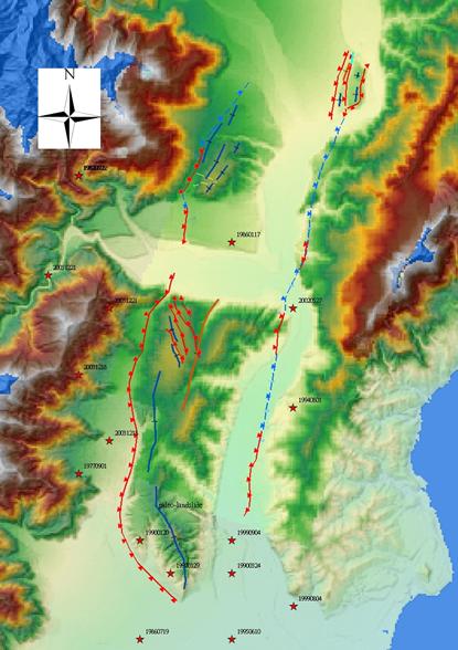
Fig.4
Several anticline at Kaotai area formed as substructures along with
thrust fault. At the southern part there is a syncline extending
to the middle of Peinanshan, forming high-angle bedding of strata
at the east limb. These strata produced steep mountains at the northeast
side. If the well-cemented conglomerates are washed-off and clastic
supported material is left, area would exposed to landslide danger.
Several anticlines appears at the west limb, and the western fault
cease activity further down south, defined by the south side tilting
terrace.
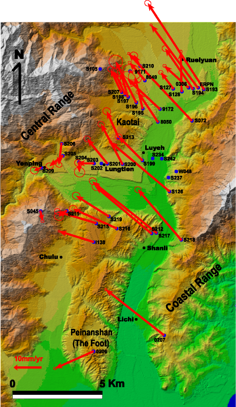
Fig.5 Gps data: reference point S105, across structure line severe
changes of deformation rate appeared. Further down south, Peinanshan
appears to be extruding southward combined with left-lateral component
slipping, thus we see damage on the Taitung Main Bridge shows similar
sense.
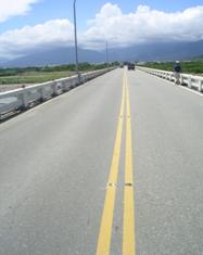

Fig.6-1 Double Yellow line bends leftward on Taitung Main Bridge.
Fig.6-2 Damage on the handrail shows clearly deformation trend.
2. Landslide
Landslide previously happened here is at central part of Peinanshan
along a old drainage, mapped on Fig.1. The size is about 1 square
kilometer dimension. In field investigation we observed some normal
faulting at the rim of the old landslide edge, cutting through by
river besides Ding-Yengwang. Edges besides the river are much steeper
than those at south and west, therefore easier to slump.
Since the contribution factors for landslide at this region are:
„« erosion by rivers create oversteepened slopes
„« heavy rain, loading from typhoon or spring plum rain season.
„« Weak strata created by washed Peinanshan conglomerate or earthquake
loosen Lichi formation.
„« Large earthquake of magnitude 4.0 and greater
We might expect either side of Peinan river to take caution for
severe erosion on
Lichi m Álange and steep strata at eastern side of Peinanshan. Along
Peinan river, fault sheared weak zone is very much erosed by the
river. Even bridgesˇ¦ base are under a large cutting rate. To the
east side, such as Lichi village formed as modern river terrace
upon deformed fault scarp, Lichi formation at the right is still
a weak zone possible to be cut-through. Other weak locations are
steeply turned eastern limb of syncline strata along east of Peinanshan,
but drainage developed at several sites are small and lack of erosion.
3. Seismic hazard
As a consequence, the 2003 Chengkung earthquake triggered upper
part of the eastern fault , besides that no clustering or major
fault-motion triggered events occurred as a consequence. It is consistent
with the seismic history given in table.1.
Before Chengkung earthquake, most events with magnitude greater
than 4 in recent 5 years appears at the south. But no obvious energy
release on certain fault plane. So we can only be ware of the active
coastal range fault at the east side for further motion. Possible
earthquake magnitude is very close to 6, if we calculate earthquake
moment by simplified fault plane geometry only for Chihshang Fault
. Regarding fault plane geometry constructed by GPS coseismic deformation
inversion (Liwei Chen, 2005), we simplified the fault as in figure
7:
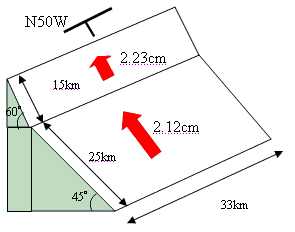
Fig.7 simplified fault plane for Chihshang fault geometry.