Research report of southern Longitudinal
Valley,
Taitung,--the present suture of the plate boundary
Po-nong Li §ő¬Ä»ú
Abstract
The Longitudinal Valley separates the Neogene island arc of Luzon
exposed in the Coastal Range and the Pre-Tertiary metamorphic basement
and overlying Paleogene slate of the Eurasian plate in the Central
Range. In the southern Longitudinal Valley, near taitung, the Pinanshan
Conglomerate forms a molasses deposit between the Coastal Range
and Central Range. We reconstruct the development of the Taitung
area by field observation, aerial photos and geodetic data. The
geomorphology of our study area is basically demonstrated by three
main faults system, respectively the Coastal Range Fault, the Luyeh
Fault and the Shanli Fault.
Introduction
Reasons for this study: As we know, Taiwan is a lively collision
area sitting on the boundary between the Philippine Sea plate and
the Eurasian plate. The Longitudinal Valley is viewed as the suturing
of two different blocks, the Eurasian continental margin and the
Luzon arc, consisting of materials derived from both the Central
Range and the Coastal Range. The onset of the oblique collision
begins at the northeastern Longitudinal Valley and progresses toward
the southwestern Longitudinal Valley. The southern Longitudinal
Valley, hence, is the latest example showing the early development
and evolution of the suturing.
We are educated that the suturing between two different blocks
ultimately merges into one big block. We canˇ¦t realize, however,
what happened during the suturing or what kind of kinematic mechanism
resulting in the suturing.
If we figure out what the basic structures is beneath the ground
in the southern Longitudinal Valley, we can know what happens during
the early stage of the suturing and image what is going to be in
the future.
Neotectonic of Taiwan: Taiwan plays a significant
role as the active collision between the Luzon arc and the Eurasian
plate (fig.1). From Oligocene to Middle Miocene time, the South
China Sea rifted extensively and formed oceanic lithosphere (Taylor
& Hayes, 1983). About Early Miocene time, the subduction of
the South China Sea lithosphere beneath the Philippine Sea plate
along the Manila trench caused the present Luzon arc (Holloway,
1982). Continued subduction leaded to the Eurasian continent margin
closer to the Luzon arc and caused an arc-continent collision in
Late Miocene time. It is the definite age of the onset of collision
in Taiwan that is still a matter of argument. The increasing amount
of clastic sedimentation in Taiwan happened about 5 Ma ago (Chang
& Chi, 1983). Thus, the mountain belt was in existence by 5
Ma.
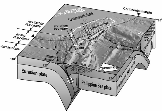
Fig.1 Block diagram showing arc-continent collision and tectonic
setting of Taiwan(by CHANG,2001)
The Coastal Range, Central Range and Western Coastal
Plain which respectively represent the former Luzon arc caused by
partial melting of the subduction plate, the accretion prism consisting
of older metamorphic rocks and the younger deposit coming from both
the continental margin and central range compose the main components
of Taiwan.
In the Taiwan area, resent GPS data show that the
North Luzon arc is moving towards the Asian continental margin with
a velocity of about 8.2 cm/yr on an azimuth of 3100(Yu, Chen &
Kuo, 1997)(fig.1). The arc-continent collision in Taiwan is an oblique
collision resulting in a time-space equivalence along the strike
of orogen, so that the onset of collision is more and more resent
from northeast to southwest (Suppe,1981).
Geology of southern L.V.: The Longitudinal
Valley separates the Neogene island arc of Luzon exposed in the
Coastal Range and the Pre-Tertiary metamorphic basement and overlying
Paleogene slate of the Eurasian plate in the Central Range. In the
southern Longitudinal Valley, near taitung, the Pinanshan Conglomerate
forms a molasses deposit between the Coastal Range and Central Range.
Coastal Range: Generally speaking,
the Coastal Range can be divided into three rock units: (1) the
Tuluanshan Fromation; (2) the Takangkou Formation; (3) the Lichi
Formation. The Coastal Range demonstrates a myriad of west-vergent
thrusts parallel or sub-parallel to the trend of the Longitudinal
Valley. Within these thrust blocks, the overlying Takangkou sedimentary
units are deformed and folded.
In the study area, the Lichi m Álange crops out to
the east of the Peinan River whereas the Peinanshan Conglomerate
is exposed to the west. Numerous striated micro-faults within the
Lichi m Álange suggest extreme shearing during the convergence between
the Luzon arc and the Central Range (Barrier and Muller, 1984).
Central Range: The pre-Neogene metamorphic
rocks of the Central Range are exposed to the west of the Longitudinal
Valley. In the Taitung area, the east edge of the Central Range
basically is made up with strongly deformed low grade Paleogene
slate and quartz-feldspars metasandstone (Stanley et al., 1981).
Peinanshan Conglomerate: The Peinanshan
Conglomerate is located in the southern end of the Longitudinal
Valley along the Peinan River, which separates the Coastal Range
and the Peinanshan Conglomerate. The Peinanshan Conglomerate consists
of a great amount of sedimentary deposits formed mainly by coarse
fluvial sediments. The total thickness of the Peinanshan Conglomerate
is more than 2000 meters. The clasts of the Peinanshan Conglomerate
are well rounded cobbles. The sediments of the Peinanshan Conglomerate
are usually derived from the clasts of the Central Range, but few
of them are derived from the Coastal Range.
Methods: First of all, we use 40m
and 5m DEM to observe the regional geomorphology of the southern
Longitudinal Valley, Taitung. With the help of the ArcGIS and ArcView
software, it is possible to examine the 3D realistic morphology
and to check the continuity and extension of structures. The aerial
photos also give us a great deal of help contemplating the details
of our study area. We can also obtain the essential information
from the geodetic data, for example, the estimation of the fault
location and the nature of the fault movement.
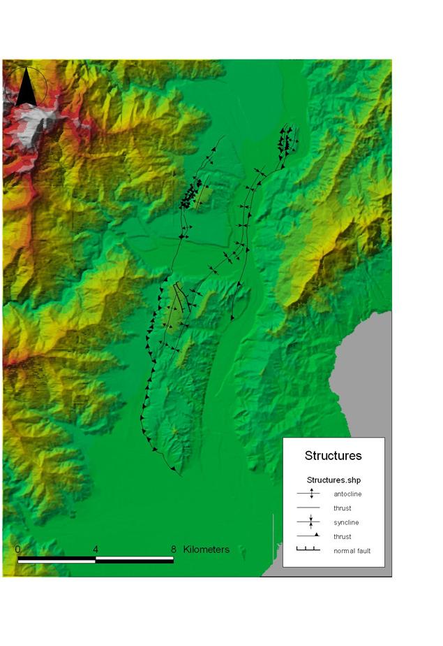
Geomprphological analysis
Summary of observations
First of all, we observe the primary geomorphology of our study
area, Taitung, with 40m and 5m DEM. We basically divide our study
area into three main domains, which is respectively Funky Blob,
Kaotai, and Peinanshan conglomerate (fig.2).
Funky Blob is a bizarre mass sitting in front of the big alluvial
fan caused by the Canasiwe River (fig.3). Funky Blob preserved the
original fan shape but was uplifted and formed a highland. The northern
side, eastern side and the southern side of Funky Blob is steeper
resulting from the erosion of the Peinan River than the western
side.
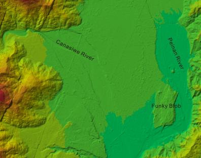
Fig.
2 Fig.
3
However, there are two main scarps sitting parallel
in the western side of Funky Blob. Kaotai is a highly deformed tableland
with gentle slope eastern limb and steep slope western limb (fig4.).
On the eastern limb, several parallel NW-SE trending streams distribute
and cut deep little valleys.
As far as geomorphology is concerned, Kaotai is an anticline formed
by the convergence between the Central Range and the Coastal Range.
Between the contact of the Central Range and Kaoati tableland a
small ridge is standing on the border. The small ridge extends from
the Lungtien terrace to 1km north away from Kaotai and terminates.
There are also some terraces spreading on the northern area nearby
Kaotai.
Peinanshan is surrounded by the Luyeh River, the Peinan River and
The Central Range(fig.5). The elevation of Peinanshan decreases
from north to south. Two main structures located on Peinanshan are
a anticline in the west and a syncline in the east. In the northwestern
part of Peinanshan, the hinge zone of the western anticline, two
parallel scarps sit on the curved surface. Both the eastern side
and the western side of Peinanshan appear clearly linear structures.
The rivers developing on Peinanshan radiate randomly.
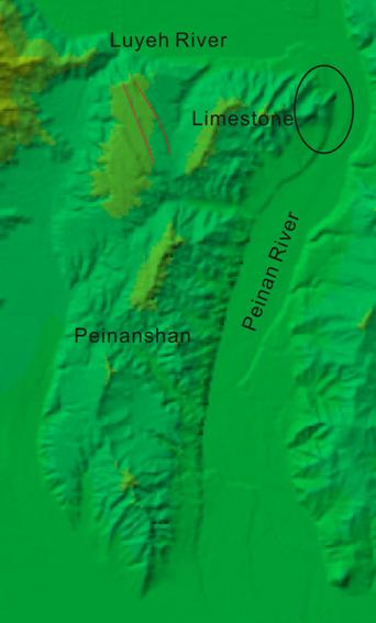
Fig. 4 Fig.
5
Field observations and aerial photos observations
Peinanshan Conglomerate:
As early mentioned, we can observe two main structures on Peinanshan.
, respectively a anticline and a syncline. Both the anticline and
syncline die out to the western linear structure. The slope of the
eastern limb of the syncline increases from west to east and reaches
the highest degree nearly vertical at the eastern side linear structures.
As to the northwestern part of Peinanshan, we can see nothing but
two parallel scarps (fig.5). At the northeastern corner of Peinanshan,
we found a contact between Peinanshan Conglomerate and limestone.
The limestone block should be part of the Lichi m Álange and dropped
down against the Peinanshan Conglomerate. From the aerial photos
we can easily note that two terraces located at northern part and
the southern part nearby the limestone block dip in different direction.
The northern one dips east and the southern one dips west.
Kaotai:
The eastern gentle slope of Kaotai tableland is covered with some
laterite which means that the age of the Kaotai is about 30000 years.
From our strike-dip data we can confirm that Kaotai tableland is
a anticline. In terms of the small ridge sitting on the western
side nearby Kaotai, the ridge is composed of Peinanshan Conglomerate
and naturally die out 1km north away from Kaotai.
Funky Blob:
As I early mentioned, Funky Blob is part of the alluvial fan caused
by the Canasiwe River. We found some imbrication indicating the
flow direction coming from west to east that means the materials
is deposited from the Central Range instead of the Caoatal Range.
On the south western side of Funky Blob, we also observed the offset
of the terraces. The amount of the offset is about 4m horizontal
and 10m vertical.
Chongye River:
In the Chongye River, we found the contact between Peinanshan Conglomerate
and Lichi m Álange (fig.6). The contact is presenting as a wide shear
zone. The shear zone is composed of strongly sheared conglomerate
with slate, schist and matrix. Above the set of the contact is a
thin layer of river deposit which was mantled by a thick deposit
of landslide materials. Behind the contact, we kept moving upstream
and fond the green volcanic rock and typical extremely stirred Lichi
m Álange. Based on this phenomenon, we consider that the strongly
sheared Conglomerate is caused by the hard green volcanic rock which
is so rigid that forced the conglomerate to become broken segments.
Furthermore, the strike-dip here changes to NE-SW direction.
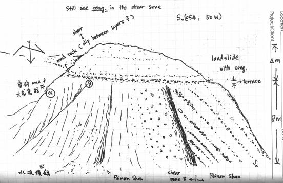 Fig.
6
Fig.
6
Geodetic observations
From GPS data (fig.7), we can easily find that the northern part
of our study area, above Shanli, possesses more thrust component
than strike-slip component. The southern part, however, possesses
more strike-slip component than thrust component.
According to the size of the vectors, we can approximately place
the thrust fault between S194 and S127 at Funky Blob. On the basis
of the judgment, we also can put other fault position between S072
and 8050, S126 and S199, S212 and S216 and 0207 and 0206.
In terms of the Lungtien terrace, we have the leveling data showing
that an abrupt uplift between S201 and S203 (fig.8). We, therefore,
consider that the high elevation region is the elongation of the
small ridge nearby Kaotai.
According to GPS data, we find that along the contact between the
Central Range and the Peinanshan Conglomerate the size of the vectors
changes a lot from eastern side of the contact to the other side.
We, hence, can place another fault basically along the contact.
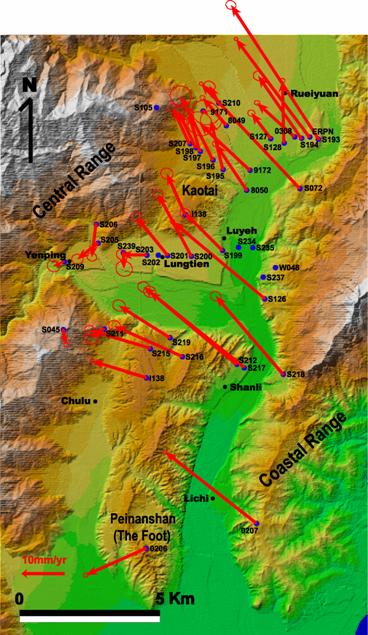
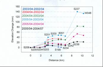
Fig. 7 Fig.
8
Analysis
From the geodetic data, we are definitely sure that three main
faults located respectively roughly along the Peinan River and the
contact between the Central and Peinanshan Conglomerate play the
chief roles in our study area. We name these three faults respectively
the Coastal Range Fault, the Luyeh Fault and the Shanli Fault. According
to the geodetic data and geomorphology, we think that the Coastal
Range Fault and the Luyeh Fault are thrust faults and the Shanli
Fault is strike-slip fault.. Both the Luyeh Fault, the Shanli Fault
and the Coastal Range Fault are active faults.
Based on the Kaotai tableland geomorphology and two main thrust
faults, we built a model (fig.9) to explain the present morphology.
In fig.9 we know that the small ridge is formed by the back thrust
and the Kaotai tableland is caused by the fault-bend fold structure.
According to GPS data, we can basically place the Luyeh Fault in
the Peinan River but we are not precisely sure the definite position
of the Luyeh Fault. In terms of the Peinanshan Conglomerate, we
also built a model (fig.10) to fit the morphology of Peinanshan.
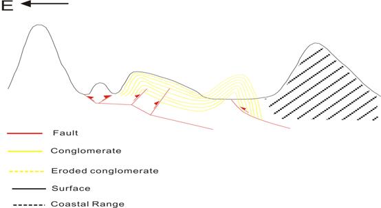 Fig. 9
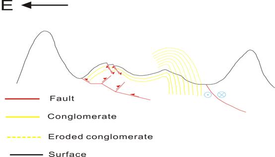 Fig. 10
As we see in fig.10 Peinanshan is composed of Peinanshan Conglomerate
and consists of two fold systems, respectively an anticline in the
western side and a syncline in the eastern side. In the hinge zone
of the anticline, we discover two parallel scarps which are normal
faults caused by the extension in the hinge zone. According to the
GPS data, we consider that the right-hand side Shanli Fault is a
strike-slip fault instead of a thrust fault the same as the Luyeh
Fault.
In the beginning, the Peinanshan Conglomerate was deformed as
an anticline and the Coastal Range Fault grew underneath the anticline.
With time goes by, the anticline is strongly deformed and the east
limb becomes more and more steep. In the same time, the east limb
became nearly vertical and a strike-slip grew in the vertical bedding
plane named the Shanli Fault. Owing to the plate convergence, the
Coastal Range Fault kept growing toward west. The west limb of the
anticline, hence, was deformed again and developed another anticline
because the Peinanshan Conglomerate collided with the Central Range.
Although the original anticline was uplifted, the erosion of the
Peinan River took the materials of the Peinanshan Conglomerate away
and create the present time morphology. Therefore, we can see nothing
but an anticline in the west and a syncline in the east on the Peinanshan
Conglomerate. We think that the anticline of the Peinanshan and
the Kaotai tableland should be the same anticline system. However,
the southern part of the Peinanshan Conglomerate shows no anticline.
It is possible that owing to the oblique collision the southern
part of the Peinanshan Conglomerate do not collide with the Central
Range and the anticline is under-forming.
In terms of the Luyeh Fault, we think that the hinge zone of the
original anticline, which is eroded away right now, is the weakest
zone which is the best way for Luyeh Fault to go through. In the
Chongye River as we mentioned, we can see a clear sheared zone between
the Lichi m Álange and the Peinanshan Conglomerate meaning that another
fault sits in the right-hand side of the Luyeh-N Fault. This fault
is named Chongye Fault. At the Chongye River outcrop, we saw a thick
layer of landslide deposits covering the set of the contact and
the landslide deposits shows no offset. Hence, we think that the
Chongye Fault is an inactive fault.
Summary
The neotectonic of our study area, Taitung, is basically demonstrated
by three main faults system, respectively the Coastal Range Fault,
the Luyeh Fault and the Shanli Fault. The Luyeh Fault and the Shanli
Fault located roughly in the Peinan River create the main geomorphology
of our study area. Owing to the continuity of the convergence, the
Coastal Range Fault kept growing and formed an frontal anticline
in the western side of the Peinanhan and Kaotai tableland. At the
present day, the southern part of the Peishan Conglomerate shows
no anticline but the anticline will gradually be made up in the
future.